
How long does it take you to hike three miles?
Three miles at a 6% grade?
Three miles with 45-degree switchbacks?
Will you be home before dinner?
Trip planning is what you do before you start a wilderness journey. And determining the distance you will cover, and how long it will take, is important for a safe and pleasurable excursion.
Stories abound of people spending unplanned nights in the wilderness because they misjudged distances and hiking speeds. Around the campfire I often hear tales where hikers were miserable because the trip was too long, too steep, or beyond the physical limits of the participants. They didn’t estimate their hiking time or effort when they planned the trip.
You can have a safe and pleasant wilderness journey by doing some simple calculations before you leave. Here are some tips to help you compute your hiking times and avoid common mistakes.
Base Walking Pace
Everyone has a base walking pace. This is the natural speed you walk. And you should be able to walk at this speed all day long. Most hikers travel at about 2 miles per hour.
Your base walking pace may change based on your age, physical condition, and the load you are carrying. For example, your base pace will be slower carrying a 40 lb. pack than if you are unladen.
There are different ways to find your base pace. Some people go to the local high school track and time themselves walking a known distance. I’m not that “serious.” I found my base pace hiking many trails where I know the total distance. I use my wristwatch to time my hike. From this data, I’ve learned my base walking pace.
When I compute my pace, I include the time spent at rest stops, viewing animals, stops to drink water and to eat snacks. My base pace right now is around 2.3 miles per hour. When I was younger, it was close to 4 miles per hour!
If you know your base walking pace, you can estimate your travel time for each hike based upon the specifics of your route. Are there steep climbs? Will you negotiate switchbacks? Will there be obstacles you need to pass?
Here is how to estimate your travel time for hikes you have never done before. But to do this you need to know your base walking pace.
Look at the Map
The most common maps hikers use to navigate are USGS 7.5 Minute topographic maps. Paper copies of these maps are available for a fee from USGS. But you can also visit websites that let you print PDF versions for free. There are also a number of reputable sites that let you customize your own map based on 7.5 Minute data.
When you look at a topo map, you need to think of it as a “wedding cake.” Each of the contour lines are the edge of a layer in the cake. Each layer is 40 feet higher or lower than the next nearest contour line.
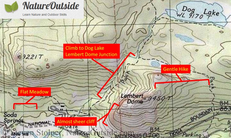
Here is a view of Lembert Dome in Yosemite National Park.
A portion of a topographic map that contains Lembert Dome, Tuolumne Meadows, and Dog Lake in Yosemite National Park. The red annotations are mine.
The dome has a sheer side. This is marked by the 40-foot contour lines packed into a very small space. You can see a gradual climb on the other side of the dome. The 40-foot contour lines are spread far apart.
The best way to access the dome is to walk across the meadow (the famous Tuolumne Meadows), which is almost flat. Notice how far apart the lines are by Soda Springs? Then climb uphill on the trail (dashed line) toward Dog Lake. You make a right turn at the junction with the pack trail and follow it around the dome. Then you can cut cross-country to make the gentle ascent to the peak.
Here is a picture of Lembert Dome taken from Tuolumne Meadows. It shows why you wouldn’t want to hike directly up the sheer side.
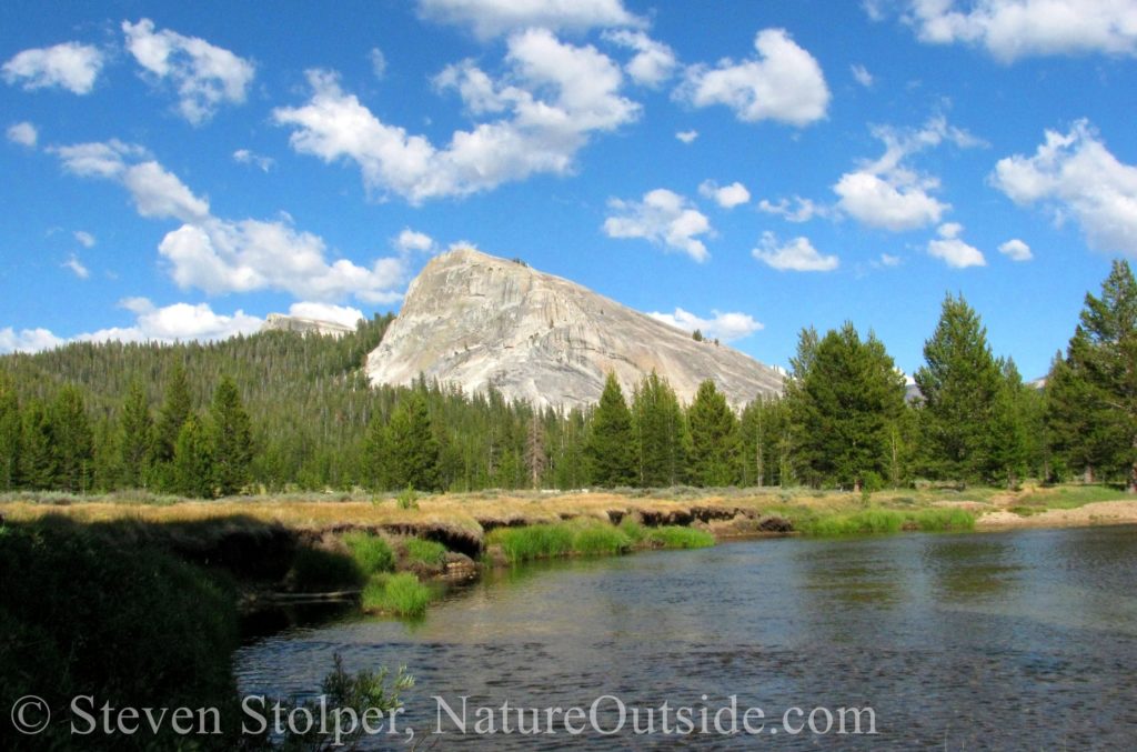
Lembert Dome as seen from Tuolumne Meadows
There are other maps with different scales than the 7.5 minute maps. Here’s a comparison of some popular maps that hikers use to navigate.
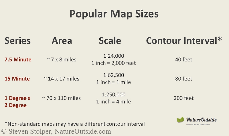
Popular map sizes used by hikers to navigate
All the information I am going to give below is based on the USGS 7.5 Minute maps.
Knowing how much elevation you are gaining, and how quickly, is important for estimating your travel time. But it can also save your life. If you travel in the backcountry during winter, knowing the steepness of slopes along your route is important. Any slope 67% or greater is likely subject to avalanche and rockslides.
Here is how you can figure out how steep the slope is just by looking at the map. You count the number of topo lines in an inch, or a fraction of an inch (like ¼ or 1/10). You take the elevation in feet (40 * number of lines) and divide it by the distance (fraction of inch * 2,000 feet). The answer is the average steepness of the slope. If you have 10 contour lines in 2,000 feet, then there is a contour line every 200 feet. This is a 20% slope. Here are some examples:
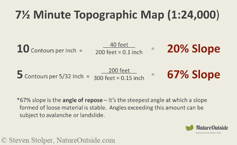
How to compute slope by counting contour lines
Know the Slope
Once you know the steepness of your route, you can picture it in your mind. Imagine how steep a climb you will make as you hike along the trail.
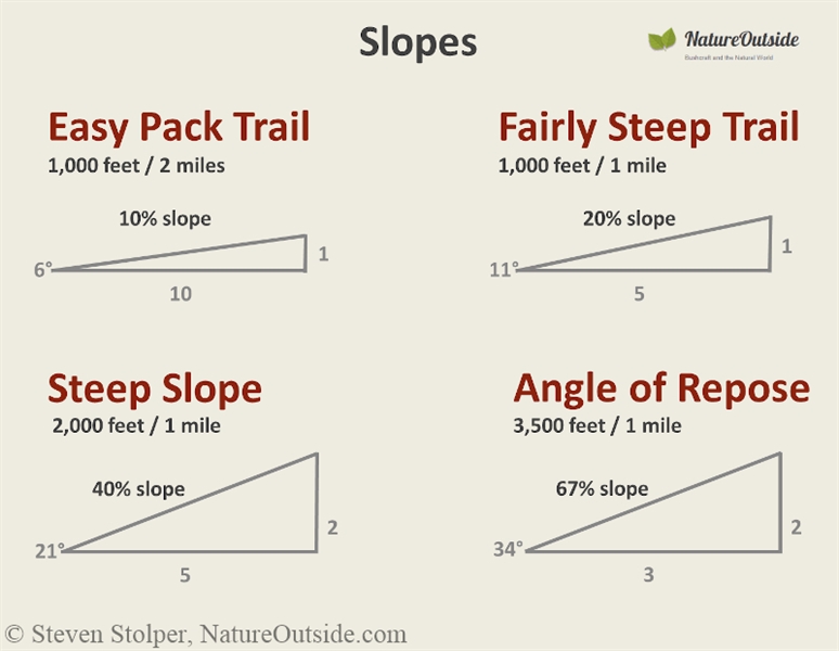
Here are some examples slopes.
Now, you can adjust your time estimate using the information below.
Adjust Your Time based on Slope and Squiggle Factor
Here is a chart that is based on outdoor experience. You can adjust your base walking time using these factors.
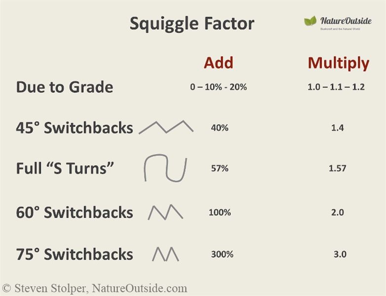
Multiply your base walking time by these factors to help you compute total hiking time. The different situations add time to your hike.
Practice Estimating Your Hiking Time
Try making some estimates and see how they work out. Evaluate the quality of your estimate. Were you able to estimate your time accurately? If not, why not?
Eventually, you will get good at estimating your trip time in the wilderness. Have fun with it and let me know how it works for you in the comments below.
Related Articles on Nature Outside
Lost While Hiking – What to do if you become lost in the wilderness
3 clever tricks to use the sun while hiking
For fun facts and useful tips, join the free Bushcraft Newsletter.


Leave a Comment