
(Photo by W. Wang)
You have brains in your head.
You have feet in your shoes.
You can steer yourself in any direction you choose.
You’re on your own, and you know what you know.
And you are the guy who’ll decide where to go.
– Dr. Seuss, “Oh, The Places You’ll Go!”
BrainyQuote.com
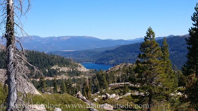
It’s a bright September day in the mountains. The sky is piercing blue above the silent spires and distant ramparts of the Sierra. My hand reflexively shades my eyes beneath the brim of my hat as I scan the terrain.
“This doesn’t look right”, I mumble. But nonetheless we hike on.
Planned Route
It was the day after the 24th annual Donner Party Hike. The previous morning my girlfriend and I participated in the festivities – a hike to the summit of Mt. Judah (8,243’) and a series of commemorative lectures. We loved trekking around Donner Pass and wanted to continue exploring the area the next day.
We decide to hike to Flora Lake. It’s a relatively flat 4.5-mile round trip to a beautifully secluded lake nestled high on the edge of a valley.
But there’s a problem. I have only been to the lake once, in 2008. The route requires leaving the main trail (the Pacific Crest Trail) and following a “social trail” past Azalea Lake and onward to Flora Lake. Would I be able to recognize the junction I had seen once eight years earlier?
I was confident I’d be able to find it. After all, I had marked the route on my topographic map many years ago. I had noted the approximate location where we depart the PCT. I was certain I’d recognize the place where we leave the trail.
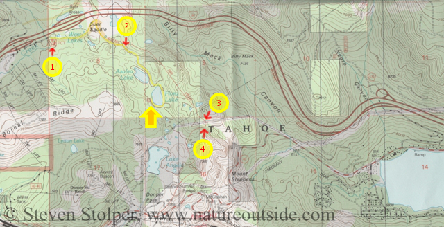
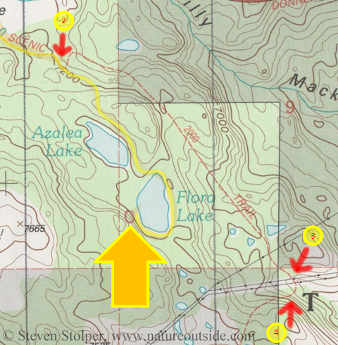
Topographic map of the area around Flora Lake. Our intended route is marked in yellow. Our destination is the west bank of Flora Lake (yellow arrow). Note Donner Lake in the lower right corner of the map.
1. Trailhead
2. Our route leaves the PCT
3. The PCT passes underneath power lines
4. The PCT curves away from the wall of the valley and begins to ascend a hill
Complacency
We start our hike along Highway 80 (Arrow #1). It’s strange to be hiking in such rugged mountains accompanied by the woosh of cars speeding between Reno and Sacramento. But after a short time the sounds of the highway recede into tranquil stillness.
The scenery is stunning! We’re high on a ridge, at about 7,200 feet, and we’re treated to a commanding view into the valley more than 600 feet below. The tans and browns of the distant mountains form a backdrop for the muted greens of the trailside pines and Manzanita bushes.
We are so high that the scene has a dreamlike quality to it. The vertical terrain make me feel like an ant crawling up the inside of a glass soda bottle.
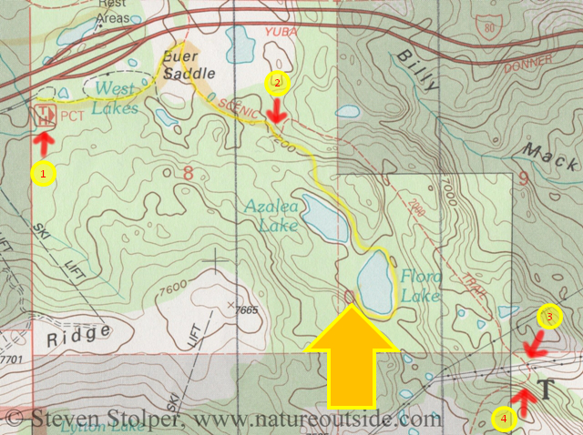
A closer look at our route, marked in yellow. We meet up with the PCT at Buer Saddle and follow along the top edge of a valley until we take a right turn (2) and leave the PCT at about the 1-mile mark.
Doesn’t Look Right
As we hike, I imagine how delighted my girlfriend will be when we reach the lake. In my mind I picture us lounging on a sun-drenched rock jutting out into the water. But eventually I wake from my reverie. Something’s not right!
My girlfriend is a fast hiker – a real Trail Tiger! We set a brisk pace as we bounce down the trail. By my reckoning, we should have reached the turnoff by now. We did pass an area where an unmaintained trail separates from the mainline and disappears behind some large rocks. Was that our trail?
We hike on.
The trail begins to take on a new look. It becomes more chaparral, with fewer trees. I don’t recall this from eight years ago.
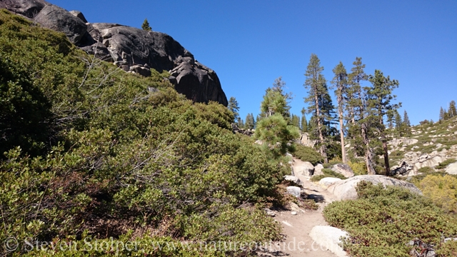
The trail becomes chaparral – Manzanita and low growing live oak line the trail.
(Photo by W. Wang)
We hike on.
We start descending the side wall of a large valley. But the valley is on the “wrong” side from the one the lake is on. I don’t remember this descent.
We hike on.
We pass underneath some huge power lines. I definitely do not recall these! Let’s go a little farther, I think. If things continue to look strange, I’ll call a halt and we’ll reassess the situation.
Finally, there is no doubt. This is unfamiliar terrain. From our position we can see Donner Lake in the distance. This is absolutely the wrong view! Donnor Lake should not even be visible.
It was time to STOP.
Our beautiful view of Donner Lake in the distance — Oops!
(photo by W. Wang)
OK, We’re Lost
OK, we’re lost. The first thing we need to do is S.T.O.P.
S – Stop
T – Think
O – Observe and Orient yourself to the terrain
P – Plan
Stop
The moment the terrain looked strange, we should have stopped walking. By continuing, we just traveled farther from our destination. Now, at least, we are confronting our situation and able to make progress toward our goal.
Think
We assess the situation. On a scale of 1 – 10, how serious is it?
Our being lost is a “2”. There’s no real danger here. We are on a well-marked trail and can reverse direction to find our way back to the car. This is simply a minor inconvenience.
Observe and Orient
We just passed underneath high-voltage power lines. I can see Donner Lake clearly in the distance. I notice the trail curving away from the lip of the valley and beginning to climb. Using this information, it’s easy to determine we are at point 4 on the map below.
Notice the power lines crossing the PCT at point 3. The trail curves away from the valley and begins to climb. We can shoot a bearing at Donner Lake (see first map near top of this page). We are clearly at point 4. Oops!
Plan
At this point, my girlfriend does something utterly alien to my being. She pulls out her smartphone! There we are, on her moving map display! The tiny red arrow matches the position I plotted on our topo map. The fix isn’t perfect. The phone shows an outflow from Flora Lake that crosses the PCT at our position. But we had crossed the dry outflow 1,000 feet up the trail.
My girlfriend makes a suggestion. The most direct path to Flora Lake is to leave the PCT and bushwack northwest. That route would keep us from having to retrace our steps.
I know the answer before I even look up at the daunting wall of boulders and sheer rock faces. Her smartphone map lacks topographic lines. It doesn’t show the 3D information my topo map does. There is more than 80 vertical feet of steep terrain between us and Flora Lake.
No, we should reverse course and follow the trail back to point #2. Then we can approach the lake over relatively flat terrain from the northwest.
Found the Lake
To make a long story short, we hike back up the trail and I’m able to recognize the turnoff from the other direction. We hiked two miles farther than we planned. But we’re none the worse for wear.
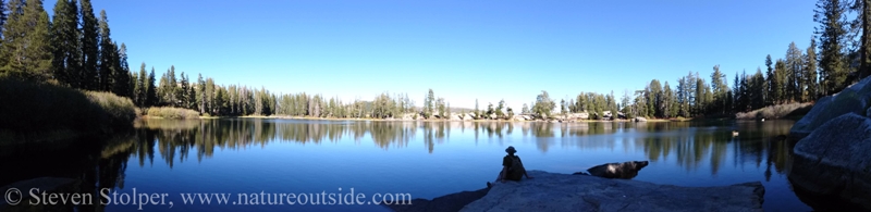
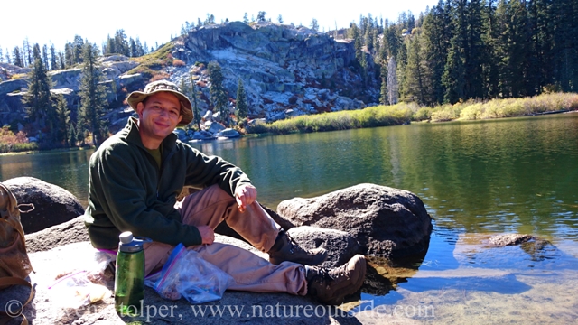
We arrive at Flora Lake later than planned. But after our unexpected detour, we’re delighted to find the lake.
(Photo by W. Wang)
Having lunch at Flora Lake
(Photo by W. Wang)
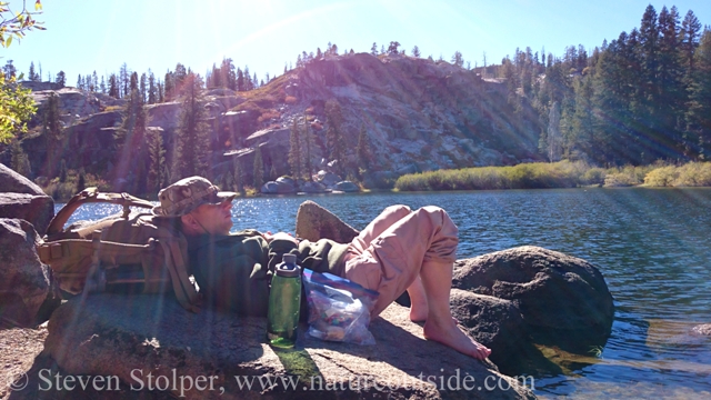
Enjoying a sun-drenched rock after a soaking my feet in the ice-cold water.
(Photo by W. Wang)
Lessons Learned
Not all those who wonder are lost. But I certainly was! All it took was a little complacency mixed with a moment’s inattention.
Let’s review my mistakes.
First, I was too complacent about locating the turnoff. I trusted myself to find the path after seeing it once, eight years earlier. Then I let my mind wander instead of paying attention to my surroundings. Even when I saw what turned out to be the correct path, I strolled past casually instead of investigating.
Then I violated the first tenant of wilderness navigation: Stay found! If I had been marking our progress on the map, I would have quickly realized we were too far down the trail. Even when I began to realize we had a problem, I continued to hike when I should have halted and assessed the situation. When lost, S.T.O.P.
In an earlier article, I discuss the importance of wilderness navigation as a skill. But having the skill is meaningless if you don’t use it when you need it. So learn all you can about wilderness navigation – It’s fun! Then make sure to use the skill on the trail. Don’t get lazy (and lost), like me!
Related Articles on NatureOutside
Bushcraft Knife Safety – 9 Tips to Avoid Accidents
Wilderness First Aid and the Duty of Care to Yourself
For fun facts and useful tips, join the free Bushcraft Newsletter.


wise warning and good info.
I hope to book a Tuolumne 5 day hike for next summer – early aug. which will be my first overnighter in Yosemite.
I’m a veteran canoeist in the Canadian Shield areas Algonquin Park and Killarney Provincial park both in Ontario. We got lost one day in a northern canoe area called Temagami. It was scary but we found our way back to the lake we had aimed for a learned a similar lesson as you just described.
The CA trip will be my first backpacking trip – at 61 yrs young!
Gary, I’m glad you found your way out. Good luck with your backpack trip! Yosemite is one of the most beautiful places on Earth. You will have a great time!
It’s coincidental I found your story about getting lost at Flora Lake. I was lost there back when I was 10 years old (1960) with a girlfriend and my mother. We were with a group, but my mom decided she wanted to go back early and find her own way back to the Lodge where we were staying in Norden, CA. Unfortunately, there were like 2 or 3 forest fires going on at the same time and the skies were very smokey and all the landmarks were not at all visible to get our bearings. We 2 girls thought we saw the cutoff of the “social ” trail, but my mom was in charge and just kept going. We ended up getting very lost in Billy Mack Canyon with 3 forest fires raging and they even sent a search party out for us. Finally, we saw a strip of highway way down a steep incline. When we got down there, we saw the search party jeep pass us from the lodge, so we were found just at dusk. I remember those power lines, and I remember my mom figuring out our direction using the sun and shadows. I also remember following those power lines and some creek beds through the rough manzanita and chapparal. I’m glad you had the use of technology and you used your intuition. My friend and I knew we were on the wrong path, but unfortunately we had to defer to my mom, who was in charge and never had a good sense of direction. It was pretty scary I will say that, especially with all the smoke and fires and getting dark.
Jo, thank you for sharing your fantastic story. It’s a lesson to us all to speak up when the little voice tells us something’s wrong. As a young girl, it must have been a scary experience. But it worked out in the end and I appreciate you sharing your experience.