
Background photo by Miroslav Vajdić for openphoto.net (cc by-sa 3.0)
I have never been lost, but I was bewildered once for three days.
– Daniel Boone, when asked if he had ever been lost in the wilderness
I love this quote! It’s humorous, self-deprecating, and shows that even the best woodsman can get lost once in a while.
That’s why land navigation is so important! Experienced outdoorsmen and outdoorswomen can get lost just like greenhorns.
And getting lost is a big deal. Many survival situations begin when a hiker, hunter, or backpacker becomes lost. It can be difficult to regain your bearings after you lose them. So the trick is to avoid becoming lost in the first place!
Refresher Course
I just completed a refresher class in land navigation. Twenty years ago I took the Sierra Club’s Wilderness Travel Course. The class had an intensive section on map and compass skills, which we practiced in a variety of terrains. So I am well-versed in using map and compass.
But since then, most of my experience has been hiking on trails. And land navigation is a perishable skill. Like so much in bushcraft, if you don’t practice regularly the skills rust and crumble to dust.
So I jumped at the chance to take a refresher class. I obtained discounted admission through the local automobile association. In the US, the most popular automobile association provides discounts to local events as a perk for its members.
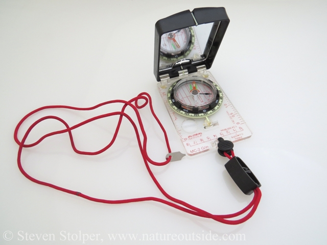
My compass. The small metal piece on the lanyard is a key that I use to “dial in” the local declination.
Our class met at 9:00 AM in the rolling hills of an open space preserve. Golden grasslands scattered with ancient oaks conceal deep ravines. At the bottom of the ravines, silent creeks wander through mixed forests of Tanoak and California Bay Laurel.
The morning was unseasonably chilly. I kept my hands in my pockets until I could retrieve gloves from my pack. The weather also had another surprise for us: dense fog! My initial reaction was disappointment. When I signed up for the class I envisioned shooting compass bearings at golden hills underneath a blazing blue sky. But I realized that this was a unique opportunity to learn. A chance to navigate in low visibility!
Despite its placid appearance, this part of California is anything but. As I glanced to my right, I could barely make out a north-south running ravine. I was looking at California’s infamous San Andreas Fault. This fault is responsible for the disastrous 1906 San Francisco earthquake. And on a clear day, I should have been able to see Loma Prieta, a mountainous ridgeline and epicenter for the deadly 1989 earthquake that bears its name.
Unlike the fog, our instructor Daniel was all sunshine. An avid backpacker and rock climbing instructor, Daniel was passionate about land navigation. And that’s what you want in an instructor – passion for his subject.
Class in Session
We set off into the fog, descending into a wooded ravine. The fog muffled our footsteps as we crept along the canyon floor. I could just make out the silhouettes of wood rose and other wild edibles taking advantage of the humid micro-climate.
Daniel made an abrupt turn and led us up the side of the gully. We climbed until we found ourselves at the top of one of the grassy hills. Mist shrouded our surroundings in all directions. With visibility down to 100 yards, it felt like we were on another planet.
Daniel asked a simple question, “How do we get back to our cars?” We spent the rest of the day trying to answer his question.
The first step in navigation is to know your location. The fog made it impossible to shoot bearings at distant peaks, trails, rivers, or man-made structures. So Daniel began to quiz us about our hike to this point. We pulled out the maps he gave us at the start of the class and began to reconstruct our travel. We finally reached a consensus about our location on the map using landmarks we remembered passing and dead reckoning.
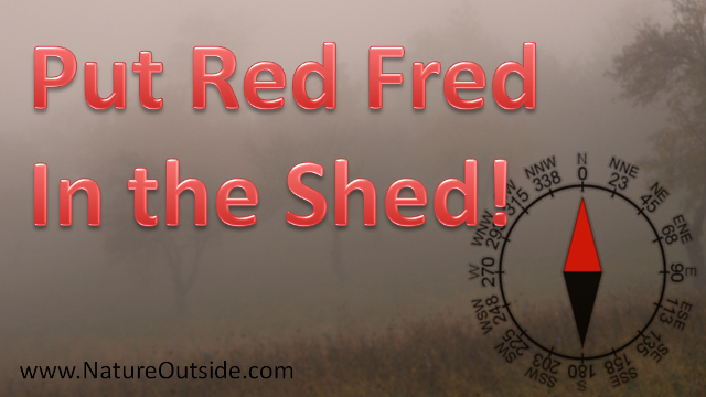
Daniel then had us orient our maps. To use a map effectively, its orientation (north/south/east/west) should align with the terrain. This is where the compass comes into its own. Daniel instructed us to lay our map on the ground, with our compass lying on top of it so “North” on the compass rose aligned with north on our map. He then asked us to, “Put Red Fred in the Shed.”
Put Red Fred in the Shed!
I had never heard the term before. The quaint rhyme instructs students to turn the compass bezel until “N” aligns with “north” notch on the body of the compass. The bezel itself usually contains a hollow arrow which points “north”. The hollow arrow looks like a little house. To put Red Fred in the shed, you rotate the entire compass body until the north-seeking needle fills the hollow arrow. The north-seeking needle is usually painted red or orange. So you are putting Red Fred in the shed.
Daniel asked us to rotate the map along with the body of the compass. So when the compass body aligned north, so did the map.
I am glossing over an important point: Declination! It turns out the magnetic North Pole of the Earth is at a different location than the geographic North Pole. The geographic north pole is along the axis of Earth’s rotation. As of this writing, The magnetic North Pole lies about 500 miles (800 kilometers) from the geographic North Pole.
So when you use a compass, you must compensate for this difference. With a simple compass, I stick a strip of masking tape on the bezel and orient my north-seeking needle to point along the strip instead of “the shed.” On my “fancy compass,” I have a key that allows me to move “the shed” to compensate for declination.
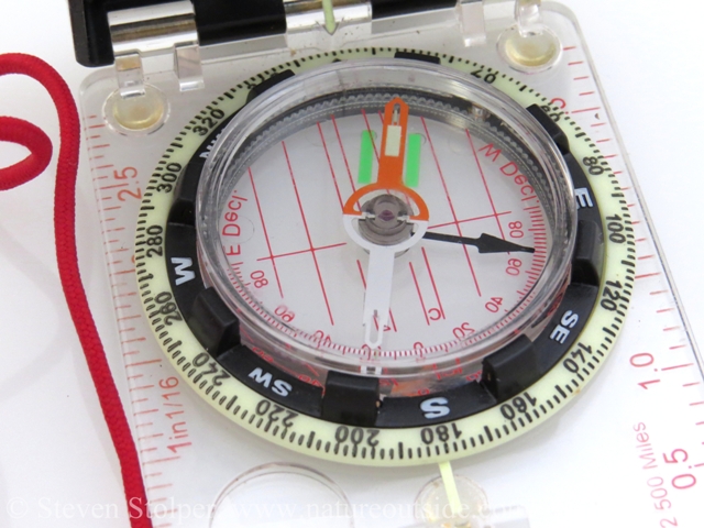
Red Fred in the shed. My fancy compass has green bars instead of a “shed.” My shed has been adjusted for local declination. The small arrow at the top of the bezel, pointing at the white line, shows geographic north.
Once I had my map aligned, I used the body of my compass to draw a line between our current location and the parking lot where we wanted to go. By rotating the compass bezel (and not the body) to put “Red Fred in the shed,” the mark on the body of the compass indicates the direction (in degrees) the class needed to travel. We picked up our maps and used our compasses to head in the indicated direction. To do this our class chose a landmark visible to us in the direction we wanted to walk. When we reached it, we found another landmark along our direction of travel and “connected the dots” until we arrived safely at our cars.
Other Navigation Techniques
This class covered only the basics of using a map and compass. But there are a variety of techniques you may want to master. One of them is “dead reckoning.”
Dead reckoning is when you estimate your current location using your last known position and projecting your estimated speeds, headings, and elapsed times. You simply figure out how long you have walked in each direction and at what speed. This is how sophisticated inertial measurement units work in airplanes and spacecraft.
I have a funny story about learning this technique. As part of the Wilderness Travel class I took 20 years ago, the instructors bussed us to Joshua Tree National Park to learn desert navigation. They divided the students into groups of three and walked us into a remote desert area. There we “sacrificed” our packs. The instructors told us to use dead reckoning to walk an equilateral triangle of about 3 miles. If we were successful with our navigation, we would arrive back at our pile of packs when we were done.
Our group of three set off, each keeping his own pace, direction, and elapsed time. I threw myself into the exercise. I had heard about dead reckoning but had never tried it. My eager scientific mind demanded that I follow the instructors’ teachings to the letter. I followed my compass bearings fanatically. I had to know: Would dead reckoning actually work?
An hour and a half later I reached the end of my triangle. I looked up with shock and disappointment. I was standing alone in the middle of the desert! My two partners, about 50 yards ahead, stood beside our discarded packs.
I tried so hard to follow the instructions! I followed them to the letter. How could I have botched things so badly?
At the debriefing, all became clear. While we were gone the instructors moved our packs!!! They wanted to make sure we didn’t cheat by looking ahead to find the pile of packs. Standing alone in the desert, I was the only one to stop at the original spot.
I learned two valuable lessons:
- Dead reckoning really works
- Don’t be afraid to have people laugh at you if you believe in what you’re doing
Map and Compass Matter
You may scoff at these skills. You may think “Why would I care about map and compass when I have my fancy GPS with moving-map display?” Well, GPS units are great… up until the batteries run out. Or they can’t find enough satellites because of the heavy forest canopy or deep canyon you are in. Maybe your unit cannot resist the siren call of the fast flowing stream you’re crossing and decides to go for a swim. Perhaps gravity takes its toll. Consumer GPS units fear gravity like Lord Voldemort.
Maps and compasses are inherently more robust than electronic devices… as long as you know how to use them.
Find Yourself
So brush up on your land navigation skills. It’s fun! Take a short navigation class and learn to use a map and compass. Or get your friends together and go on a “navigation hike.” Then graduate to GPS navigation.
Having these skills allows you to enjoy the freedom of bushwhacking instead of being tied to maintained trails. It also lets you explore using ancient maps and discover new and exciting places no longer recorded on modern maps.
Be sure to let me know what you’ve done in the comments below!
Other articles on NatureOutside
The High Sierra Loop – Sunrise Camp to Merced Lake
Off the Map Adventure – The Sandstone Caves
If you enjoyed this article, you may want to check out others in the Trips and Skills Sections.


Leave a Comment